| Name
|
Size
|
Creator |
Creation Date
|
Last Modification Date
|
Labels |
Attached To |
|
PDF File Add ILIS Support Mailbox.pdf |
237 kB |
Michael Saunders |
Oct 17, 2023 13:50 |
Oct 17, 2023 13:50 |
|
Page: ILIS (Integrated Land Information System) Support
|
|
PNG File image2022-2-18_12-28-34.png |
15 kB |
Matthew Winston |
Feb 18, 2022 12:28 |
Feb 18, 2022 12:28 |
|
Page: NT Visualiser - How to load historic imagery globe
|
|
PNG File image2022-2-17_16-12-2.png |
10 kB |
Matthew Winston |
Feb 17, 2022 16:12 |
Feb 17, 2022 16:12 |
|
Page: NT Visualiser - How to load historic imagery globe
|
|
PNG File image2022-2-17_16-10-49.png |
10 kB |
Matthew Winston |
Feb 17, 2022 16:10 |
Feb 17, 2022 16:10 |
|
Page: NT Visualiser - How to load historic imagery globe
|
|
PNG File image2022-2-17_14-6-46.png |
10 kB |
Matthew Winston |
Feb 17, 2022 14:06 |
Feb 17, 2022 14:06 |
|
Page: NT Visualiser - How to load historic imagery globe
|
|
PNG File image2022-2-17_13-58-56.png |
10 kB |
Matthew Winston |
Feb 17, 2022 13:58 |
Feb 17, 2022 13:58 |
|
Page: NT Visualiser - How to load historic imagery globe
|
|
PNG File image2022-2-17_13-54-56.png |
10 kB |
Matthew Winston |
Feb 17, 2022 13:54 |
Feb 17, 2022 13:54 |
|
Page: NT Visualiser - How to load historic imagery globe
|
|
PNG File geo1.png |
39 kB |
Justin Boencke |
May 13, 2020 15:05 |
May 13, 2020 15:05 |
|
Page: NT Visualiser - Geocoding and labelling using street addresses
|
|
PNG File geo2.png |
34 kB |
Justin Boencke |
May 13, 2020 15:05 |
May 13, 2020 15:05 |
|
Page: NT Visualiser - Geocoding and labelling using street addresses
|
|
PNG File geo3.png |
42 kB |
Justin Boencke |
May 13, 2020 15:05 |
May 13, 2020 15:05 |
|
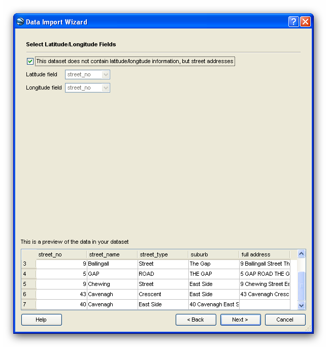
Page: NT Visualiser - Geocoding and labelling using street addresses
|
|
PNG File geo4.png |
35 kB |
Justin Boencke |
May 13, 2020 15:05 |
May 13, 2020 15:05 |
|
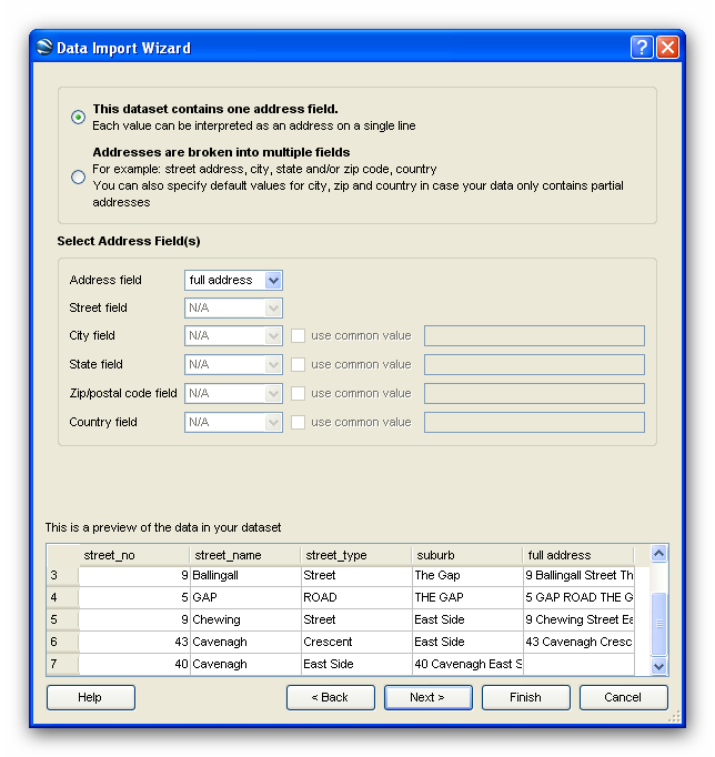
Page: NT Visualiser - Geocoding and labelling using street addresses
|
|
PNG File geo5.png |
15 kB |
Justin Boencke |
May 13, 2020 15:05 |
May 13, 2020 15:05 |
|
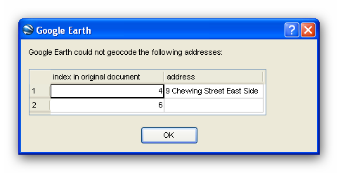
Page: NT Visualiser - Geocoding and labelling using street addresses
|
|
PNG File geo6.png |
13 kB |
Justin Boencke |
May 13, 2020 15:05 |
May 13, 2020 15:05 |
|
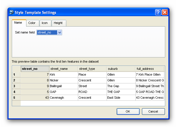
Page: NT Visualiser - Geocoding and labelling using street addresses
|
|
PNG File geo7.png |
28 kB |
Justin Boencke |
May 13, 2020 15:05 |
May 13, 2020 15:05 |
|
Page: NT Visualiser - Geocoding and labelling using street addresses
|
|
PNG File geo8.png |
891 kB |
Justin Boencke |
May 13, 2020 15:05 |
May 13, 2020 15:05 |
|
Page: NT Visualiser - Geocoding and labelling using street addresses
|
|
PNG File spatial_direct.png |
0.3 kB |
Justin Boencke |
May 13, 2020 14:46 |
May 13, 2020 14:46 |
|
Page: Online Applications of the NT Spatial Data Infrastructure
|
|
PNG File sdi.png |
21 kB |
Justin Boencke |
May 13, 2020 14:46 |
May 13, 2020 14:46 |
|
Page: Online Applications of the NT Spatial Data Infrastructure
|
|
PNG File owner_name_identification.png |
59 kB |
Justin Boencke |
May 13, 2020 14:44 |
May 13, 2020 14:44 |
|
Page: Owner Name Identification tool for ArcGIS -
|
|
PNG File ownername_identification_screenshot2.png |
62 kB |
Justin Boencke |
May 13, 2020 14:44 |
May 13, 2020 14:44 |
|
Page: Owner Name Identification tool for ArcGIS -
|
|
JPEG File ArcGIS_WMS1.JPG |
56 kB |
Justin Boencke |
May 13, 2020 14:40 |
May 13, 2020 14:40 |
|
Page: Viewing NTG Aerial Imagery in ArcGIS
|